Our decision to escape our home for the duration of Audrey’s school’s weeklong Spring Break proved most refreshing. We would say “rejuvenating,” but the joint pops and bone creaks of our early 50s years leave us satisfied with “refreshing” while thinking nostalgically of when we were truly “juvenated” without the need for the “re” part. As we planned the six-hour drive from our home in the Panama City suburb of San Miguelito to Cambutal, midway along the Pacific coast of Panama’s Azuero Peninsula, we hoped the adage “Getting there is half the fun!” would come close, if not apply fully, to describe the trip.
Once we had made our reservation at Sansara Surf & Yoga Resort a few weeks ahead of our escape, Brian did his standard plan-for-all-contingencies über-preparations. (NB: That is not Über, for we would drive ourselves; but über, because he has superhuman contingency planning skills that Audrey accepts with loving grace and, after 25 years of marriage, without too many eye rolls.) As such, he printed out turn-by-turn maps from San Miguelito along Corridor Norte to Via Centenario to take us over the Panama Canal on the Puente Centenario (Centennial Bridge, opened in 2004, a century after construction on the Panama Canal began in 1904, as only the second permanent bridge over the Canal); along the Autopista Panamá-La Chorrera (Panamá-La Chorrera Highway) to connect with the Carretera Interamericana (the Central American section of the Pan-American Highway); then turn south onto Avenida Dr. Belasario Porras (named for Panama’s sixth President just 11 years after its 1903 independence from Colombia, who served for 10 years in three terms spanning 1912-1924) to follow the peninsula’s coastline south and then west to Cambutal.
Cue Audrey: “Well, we need to pack for lots of different things…clothes to stay a week, plus yoga, snorkeling, dining, shoes…I do not think this is too much. And what is all that stuff that you are putting into that extra suitcase?”
Cue Brian (and his über-preparations): “I have two 5-liter bottles of water, because we do not know what the water situation will be like. I have enough Coke for me to have my daily bubbly caffeine. I have some wine and other things for evening refreshments, including that bottle of Fonseca 30-year Port we can crack for our four-months-early 25th Anniversary celebration, because there is no place for miles to pick up anything we might want. I have snacks so we do not have to stop anywhere along the way for food and so we have stuff to munch on in our room during the week as a supplement for the extra-healthy food the restaurant will serve. Anyone who tries to pick up this bag will think we have a body inside it.”
After loading many more supplies than we ought to have needed into the back of our car, Brian offered Audrey a pre-anniversary present by giving the “All aboard!” call more than a half hour ahead of our planned 9:00 am departure time.
Traffic flowed easily for us all the way across the Puente Centenario while we saw all lanes coming in the other direction stalled, extending out from both ends of the bridge for at least a couple kilometers. (With only two bridges across the entire southern half of the Canal, traffic backs up heavily even on weekends, and weekday traffic can turn a 30-minute trip across the bridge into one lasting several hours.) Then as we continued along the Autopista Panamá-La Chorrera we slowed to stop-and-go traffic as well. That made it easy for us to view the surroundings as we crawled toward the Carretera Interamericana. Before long we realized this lone spine shooting westward through “the Interior” carried us through one battleground after another in what we dubbed La Guerra de la Red Móvil (the Mobile Network War). Like school sports programs in the U.S. seem owned by either Coke or Pepsi in the infamous Cola War, each town of Panama’s Interior seemed aligned by ubiquitous exclusively bright blue or red advertising (across pedestrian overpasses, encompassing bus stop shells, even on the sides of buildings and walls bordering the roadway): blue for Tigo or red for Claro, the two big mobile phone networks in Panama.
The further out from Panama City we drove into “the Interior,” the more surprised we were to discover the central Pacific Coast’s non-rainforest climate of el Arco Seco, the Dry Arc. The Dry Arc starts in Panama Province around Coronado; wraps westward through Coclé Province around the Gulf of Parita into Herrera Province; and southward into the eastern half of the Azuero Peninsula through the large town of Chitre (Capital of Herrera Province with a metro-area population of 80,000 people) and into Los Santos Province’s Las Tablas (Capital of Los Santos Province with a population on the upside of 9,000 people), Villa de Los Santos, and on to the seaside village of Pedasi.
Except that we did not see Pedasi on our ingress trip, because Audrey’s near-religious dedication to Waze had us depart from Brian’s just-in-case maps printed out from Google Maps. Instead of hugging the Azuero Peninsula’s coast as Brian had pre-navigated, after we passed through Chitre and approached Villa de Los Santos, the very American (i.e., bad Spanish) pronunciation of Spanish road names in Audrey’s Waze routing instructed that Brian should detour from his coastal route to zip diagonally across the peninsula. When Brian sought to note politely that the different route was, indeed, different from what he had planned in his über-preparations, Audrey emphasized…more emphatically…the emphatic need for him to detour as instructed by Waze.
This navigational incongruence actually carried more weight accumulated through the last several years of mostly marital bliss than the immediate moment might imply. In Casablanca, Audrey eschewed Google Maps because it often took us to places other than where we wanted to go. On numerous occasions we typed in a destination and followed directions only to find ourselves with no idea where we were or how close we were to our intended target stop. Instead, Audrey liked Waze for its nimble routing that could alter course based on immediate traffic circumstances and, more likely than not, actually take us to our intended destination. Brian acknowledged the shortcomings of Google Maps, but liked its start-to-finish route maps so he could see the big picture of the prescribed route, progress along said route, and see other routing options that allowed him to call audibles while on the road (which, for the record, literally drives Audrey mad). Mostly, he did not like Waze’s propensity to take us through the narrow roads of Casablanca’s old city medina at every possible opportunity, because we drove a big Honda Pilot that Waze would quickly get stuck in a cramped street scene not much wider than our vehicle. More than once, despite Brian’s protestations, Waze (and Audrey) made us drive our huge tank into the medina, which then required the assistance of kindhearted Moroccans to help us turn around or steer past obstacles and small children in streets of shrinking breadth. Panama is different. There is no medina. Brian defaults to Waze on his Panamanian phone to navigate around town. But for start-to-finish map planning, he prefers to use Google Maps. Nonetheless, leaving San Miguelito at 8:49 am on a six-hour drive to Cambutal, Audrey made clear at the outset that Brian would not fail to respect her Navigator role while he drove. He would choose not to follow Waze at his own peril.
So, rolling into Villa de Los Santos, when Audrey told him to turn right and he said that was not the way his über-preparations told him to go, Audrey told him differently, in the most loving of forceful ways, insisting that Waze said it would be 30 minutes shorter a trip. Little did she know that saving 30 minutes on the drive would take more than 30 minutes off of our lives.
Audrey continued to gaze out at our surroundings, but Brian could grab only glimpses here and there because the road became one narrow lane in each direction with no shoulder to guard us often from levee-like drops. As we climbed in elevation, Audrey began sharing presages of what she called “curly-cues” on the map. Falling entranced by her map-reading, she described what she saw on her phone screen as different body parts that she hoped would give Brian some sense of how the curly-cues combined in the roadway ahead: “Next it looks like an ear…so now we’re driving down around the earlobe and there will be a REALLY TIGHT curly-cue before it gets more straight for a little while, then it bends around the top of the ear and then there is another REALLY TIGHT curly-cue” or “Okay, this one is like a nose, so we’re starting with a bit of a curly-cue to get onto the bridge of the nose, then it is straight for a bit before a REALLY TIGHT curly-cue at the bottom of the nose and another REALLY TIGHT curly-cue around the nostril.” Brian, figuring she suffered a mild case of altitude sickness from slight oxygen deprivation, stayed focused on the road and just drove slowly and conscientiously while pretending to have some inkling of what she described.
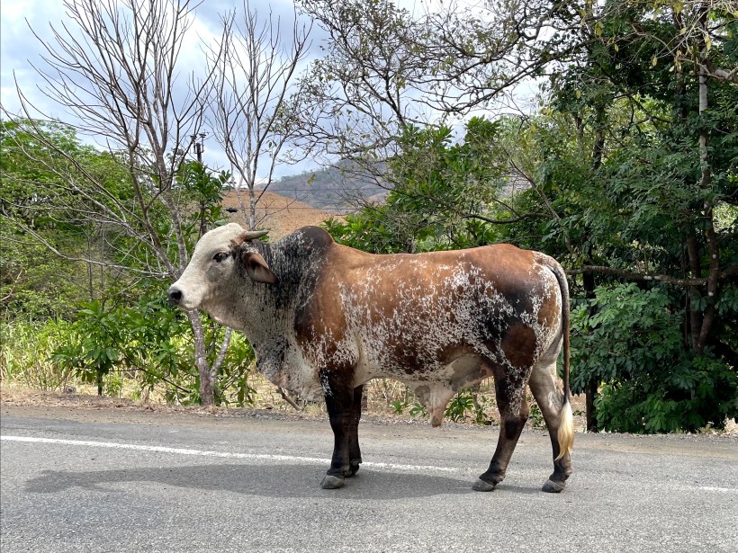
Whether from Audrey’s gazing looks or Brian’s glimpses snatched along rare straightaways, we puzzled over how differently the scenery looked from what we had expected. This was not the lush and all-encompassing rainforest we imagined, looking more like grazing land of the cattle ranches in the western U.S. We saw cows and horses (including people riding horses along the roadside as their choice of transportation) instead of sloths and monkeys. Later we learned that the area’s long history of cultivation and grazing turned the peninsula into one of Panama’s most heavily-deforested parts of the country.
Winding through the curly-cues and past the cows and horses, Audrey kept calling out our remaining distance and time for arrival in Cambutal, and we wondered when we would descend from the hilly highlands to see the Pacific coast. Even when we noticed that we drove down more than we drove up from incline to incline, it still felt a world away from a coastal scene. Then, rather suddenly, we whipped around some more curly-cues and saw the Pacific Ocean laid out past the trees ahead. The road cut to the right and turned west to run parallel to the coast as we moved through the sparse collection of houses and small hotels on either side of the road that made up Cambutal. At the end of the road we found Sansara Surf & Yoga Resort, parked, and left the cadaver bag and other über-prepared supplies in the car while we walked across the street to register for a week of escape and decompression.
On your mark, get set, here we go!
